Based on the location and focal mechanism of the earthquake (https://earthquake.usgs.gov/earthquakes/eventpage/nc75095651...), this is a strike-slip earthquake on the plate boundary between the Pacific and Gorda/Juan de Fuca plates. Strike-slip earthquakes occur when two plates slide beside each other during an earthquake, usually along a steeply-dipping if not vertical fault. These kinds of earthquakes almost never produce damaging (or even really noticeable) tsunamis because there is no real displacement of sea water by seafloor movement, unlike a thrust or subduction zone earthquake.
The USGS's automated systems calculate the location and focal mechanism/moment tensor pretty much instantly from the seismic network. The system should know that a significant tsunami is unlikely based on the parameters of the earthquake. On the one hand, it's good to be cautious, but on the other hand, a system designed to cry wolf is also self-undermining. Maybe they should have a tiered warning system?
Doesn't any earthquake, regardless of fault type increase the immediate risk of a submarine landslide?
There are many steep canyons on the Pacific coast, and here is just one example of mass casualties from a tsunami resulting from a submarine landslide triggered by a strike-slip fault earthquake:
Caltech, 2018[1]: "Contrary to Previous Belief, Strike-Slip Faults Can Generate Large Tsunamis"
Yes, the probability of tsunamogenic landslides do increase during earthquakes, but it's still quite unlikely for an event of this magnitude tens of km from the continental slope; this is why a properly-calibrated tiered system would be better.
The reason that the Palu event is so notable is precisely because it's uncommon. It's also a very different system: the causative fault is running along the axis of a shallow bay that is only a few km across, so even if the landslide did occur, rapid movement of the steep, shallow coastlines would surely have generated a smaller tsunami. It's a geographical and tectonic situation in which at least a minor tsunami is expected a priori conditional upon an earthquake, so a warning system would account for that in principle. (In practice there isn't time enough to mobilize because the tsunami hits while the ground is still shaking). The bay at Palu is like a somewhat larger Tomales bay--an earthquake right there is going to make some waves. Very different situation than one far off shore.
> Yes, the probability of tsunamogenic landslides do increase during earthquakes, but it's still quite unlikely for an event of this magnitude tens of km from the continental slope; this is why a properly-calibrated tiered system would be better
There is a tiered system, its calibrated based on a combination of magnitude and warning time for the initial alerts (updated notices are based on other measurements and observations, but if gathering and analyzing observations before an initial warning doesn't leave time to act on it, it doesn't matter how accurate the warning is.)
I've been subscribing to tsunami warning system emails since the mid or late 2000s. They send the first email about the earthquake as a warning that something happened. Then after ,if a tsunami isn't detected they send an email saying that. If there is a tsunami they will send the first warning and as soon as sensors and satellites start to track the wave they will update at intervals with a table of expected arrival times and magnitude or height. So, yes, they send a warning that something happened, then they send information if there is a threat.
Here is an example of the first message sent 9 minutes after 2011 Tōhoku earthquake https://imgur.com/a/1mwAKqc.
> The USGS's automated systems calculate the location and focal mechanism/moment tensor pretty much instantly from the seismic network.
According to a USGS guy on the news just now, this isn't true. They know the location, and the magnitude, but the moment tensor takes time. Therefore any ocean earthquake 7.0 or above triggers an immediate tsunami warning.
HN has good SnR generally, but I would default to trusting their automated system more than Random Internet Guy. Even if the warning gets canceled after measurements become available.
You definitely sound like it. But man, I've met some convincing liars online so I try to be cautious when someone makes claims and I have no proof that they are who they claim to be (especially when they didn't make that claim explicitly, and just sound very intelligent).
It's a complication that will never happen, but sometimes I think it would be cool if HN had a way of authenticating experts and giving them flair. So many legit smart people here.
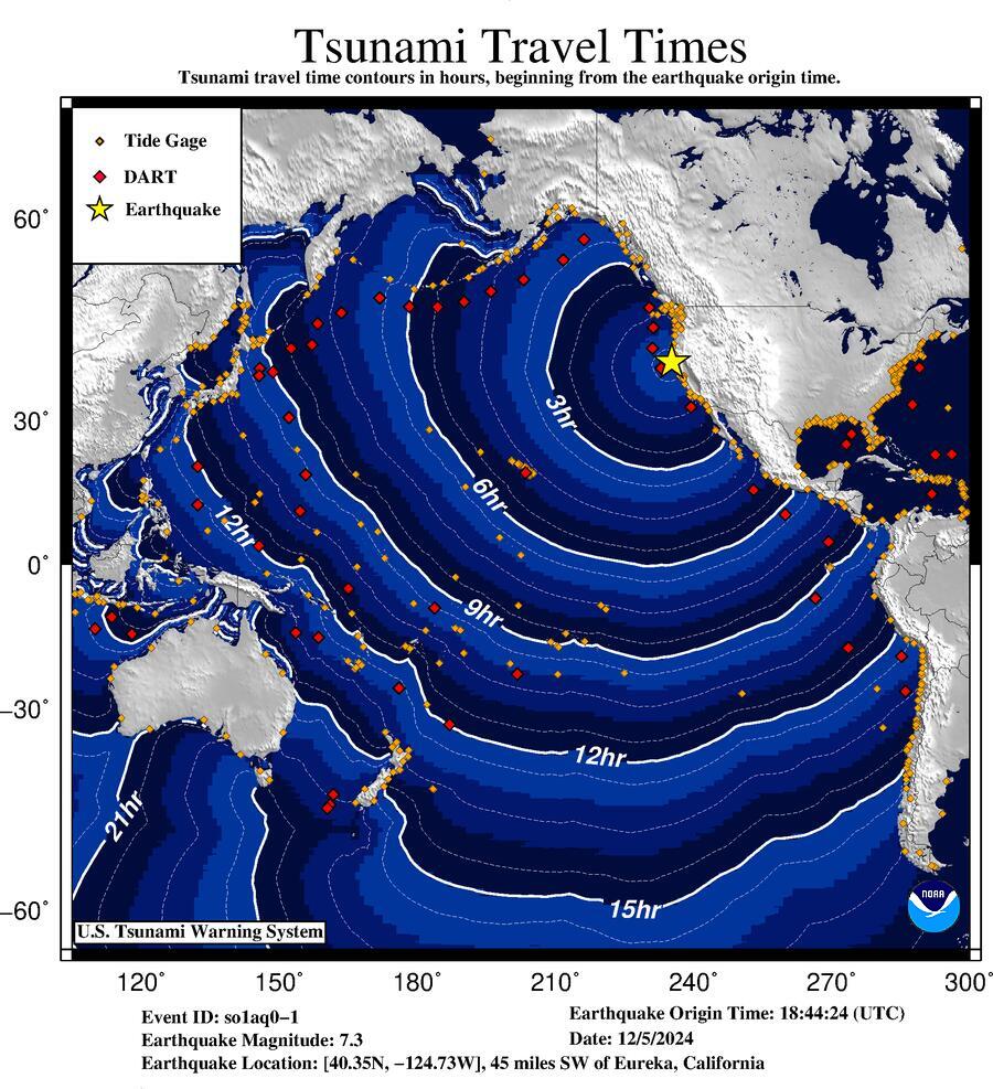
Based on the travel time map, and that the earthquake event was just 45 mi SW of Eureka, CA (and potentially closer to the coastline elsewhere), it seems that jumping straight to Tsunami Warning is the most appropriate messaging, given that the expected time to impact is quite short?
It's a three-tier system, I was confused when I was looking at it. The fourth item is "threat" which you would think is higher than "warning", but "threat" is only used outside of the US.
The system is training me to ignore it already. I’m in SF and we had a flash flood emergency alert. I never heard of or saw any floods. I could believe a street or two might have had a few inches of water at most. But honestly I’d bet against even that.
There was a ton of flooding on flat roads and highways during the last week+ long storm session. I saw several lanes impassable on 101, and several spots in SF where a car could easily have gotten flooded.
All the alerts I got were basically "please don't drive" and not "you're gonna die!", which I think is totally reasonable.
I've gotten the warning and my street is perfectly fine... and then I look at social media and cars on the street are half-submerged just 20 blocks away.
You might not even be aware of elevation differences when they're gradual.
It is also unclear to me how someone is supposed to differentiate a real emergency from an "Extreme threat/danger" and what authority they should look to, besides their common sense.
I guess people can go on twitter and read some random posts.
Flash flood alerts are one of the few that I don't get annoyed about seeing. A big rain up in the mountains can result in a huge chunk of water somewhere downstream a couple of hours later. This significant displacement of time and space between cause and effect warrants caution and notification.
This is similar to the "severe weather alert" I just received on my phone when the temperature will range from 47' to 67' F (8' to 19' C) in Los Angeles today, December 5, with clear, sunny skies and no noticeable winds.
Of course, when I tap on the notification and open the app, I see that it's actually driven by an air quality alert because the AQI will be 112 (which isn't even that high.)
Come on guys - the dictionary defines weather as, "the state of the atmosphere with respect to heat or cold, wetness or dryness, calm or storm, clearness or cloudiness."
Also confusing when the SF Fire captain is on the radio telling people to evacuate to 100 ft above sea level right after a CalTech seismologist says it is unlikely to cause much of a tsunami due to being a strike-slip earthquake.
Yes, it's a big one in my formative years as a kayaker. I've used the handle in a lot of places and I think you're the first person that's recognized it.
I loved the days when people could/would set up webcams like this. Just to see outside and share it with others. They're getting so much harder to find.
This is quite relaxing, I agree. Here's a couple from Pacifica, CA for you.
surfline.com has them all over the world, but you have to pay $9/mo to watch them (I have a sub for surfing info). They have a 24h rewind feature which is pretty cool. People use it sometimes for video of themselves surfing, but I guess it would also be useful for random events like tsunamis.
On that note, I checked feeds at both Ocean Beach and Linda Mar at the predicted time but didn't see anything unusual, except that they apparently made all the surfers get out (first time I've ever seen Linda Mar empty of surfers during daylight hours apart from big storms/flat spells). OB had a bunch of spectators lined up on the dunes... an interesting reaction to a tsunami warning is "let's go to the beach and watch!".
     * Where time and conditions permit, move your boat out to
       sea to a depth of at least 180 feet.

     * If at sea avoid entering shallow water, harbors,
       marinas, bays, and inlets to avoid floating and
       submerged debris and strong currents.
typically, yes. Tsunamis are usually unnoticeable away from the shore. They aren't like a massive, traveling, cresting wave. They are usually a pulse of high energy that can move a lot of water just a few feet, which can be devastating when it reaches the shore because it is relentless as it moves up to that height.
Presumably, but this is near the focal point of the earthquake, and surge should have arrived 8 minutes ago as I write this. No indication of any water level change. I think this was a false positive.
I have had lunch there, can confirm. Though I think the best food in the harbor is at Noyo Harbor Inn. The Wharf was pretty good for an old-school seafood restaurant.
Likewise. Stopped in on a whim, and was pleasantly surprised. Delightful little area in that harbor, and the food was better than expected. I appreciate the surprise nostalgia from this webcam. :)
There are a handful of good restaurants (e.g. Sea Pal Cove) and a nice off-leash beach beach there despite it being a very sleepy corner of the small city.
Interesting observation: I am in a circumstance where I am transitioning from an Android phone (Samsung Galaxy) to a iPhone. I observed that android phone alerted me about an earthquake and that I should be ready to feel tremors. To my surprise as I was pondering how this system works - especially wrt to latency - where it alerts me head of time, I then fell small tremors in 2 or 3 seconds after the alert. The tremors were very small and I would not have noticed it if it weren’t for the alert. ~10 (may 15 minutes) later, the IPhone gave a tsunami warning which I take it was due to the earthquake.
What I was surprised by is how behind the iPhone was. I expected iPhone to be on par with android in terms of safety alerts.
Anybody know if there is a way to get the early alerts on iPhone like I did on the android phone?
In general my impression of Android is that it’s quite ‘leaky’ and apps can abuse it quite easily and iPhone is more secure. Would love to hear thoughts on this or point me to resources that address this question.
LTE ETWS/PWS is mandatory feature, iPhones has the same thing. Maybe you've explicitly disabled it, considering (IIUC) US used it for AMBER alerts and had annoyed lots of people at some point.
Generally an earthquake warnings are issued by someone always automatically correlating sensors everywhere, USGS and/or NOAA in case with US, and then cellular carriers broadcasting the alert through LTE feature. This does not work without participating local equivalent of USGS deploying a sensor network and running its computers wired to carriers.
This feature is carrier agnostic, enabled by default, and mandatory on phones; it's specifically designed to deliver earthquake early warnings. It does not matter if it's Android, iOS, or something else altogether. Any phones, SIM locked or unlocked, with or without SIM, should start blaring the alert so long it hears the signal.
I think OP is describing a different feature. It's not a carrier feature like Amber alerts but an OS feature. Google documents this feature here: https://crisisresponse.google/android-alerts/ I'm fairly certain this is due to some Android-specific code inside GMSCore. It has nothing to do with carriers.
On iOS you have no such thing and you either rely on the carrier alert (there won't always be one) or install an earthquake alert app such as MyShake.
The wireless emergency alerts (like what you see for amber alerts) that go over cell towers have pretty high latency (IIRC on the order of a minute or two for the alert to disseminate). The native Android earthquake alerts are much faster
Carrier alerts is the fastest. Not only the whole process from detecting tremors to alerts take 30 seconds or so, there aren't other data sources than what those carriers use anyway, so there's just no way Google can be faster than carriers.
PWS is also a broadcast, meaning the phones don't have to wait for cellular timeslots, so it's faster and bandwidth efficient in that regard too.
Unfortunately the architecture of IPAWS can introduce fairly long delays. The EEWS system uses a dedicated channel to deliver alerts to WEA more quickly, since a study by USGS/NIST had determined that IPAWS could not meet time objectives (typically ~5 minutes end to end). The tsunami warning center, like basically everyone except for USGS, has to originate alerts through IPAWS. The performance and latency problems with IPAWS have been flagged by GAO a couple of times now but it's not something that receives much investment. All-Hazards Radio (weather radio) should actually be a faster alerting mechanism for tsunamis, in practice, since NOAA operates that system themselves.
The Android Alerts are actually coming off of IPAWS as well, but I believe they take a feed directly from the publishing system and do all of the routing themselves. Their implementation is of course quite a bit faster than IPAWS rather creaky and sort of batch-centric architecture.
I got shake alert via google play services. I have amber alerts on. I have gotten earthquake alerts over WEA in the past. I did not get one this time. I am pretty sure one was not issued for the 6.9 magnitude quake just the tsunami
For folks jumping on saying "that's not a carrier thing". All comms are a carrier thing. Whether it's ETWS, SMS, or IP, it's going through the carrier, they process it, and they do extensive traffic management. Carriers absolutely can and will inspect, proxy, aggregate, and do anything else that will tease out another few % of "free" capacity.
[Edit:] All too real scenario: Carrier knows about particular IP addresses and ports used by alert service. Carrier makes provision for separate path for it. Carrier also tries to shave said provisioning to the bone, calculates a worst-case, and adds 5% capacity. Which doesn't get updated when that particular app gets a 6% boost in subscriptions. Back in the old days the traffic management folks would be on top if it, but that's all been outsourced...
PWS is tower based broadcast. Everyone within range of a tower gets the alert. Data source is supposed to be local government weather authority, I think USGS and NOAA in US. Or the Meteorological Agency in Japan.
You can do a location-based two way warning system and there are such services, but it's going to be laggy and won't scale to 100M+ simultaneous subscribers. One-way broadcast scales to the planet if wanted.
It doesn't sound like the iPhone was behind, but rather warning about something else? It's interesting that Android didn't warn about the tsunami at all, even though that sounds more important than the barely noticable tremors you describe.
The tsunami warning was in effect all the way down to Santa Cruz. The earthquake alert is sent only if you are expected to experience some particular level of shaking or higher in your location.
It varies, a lot, and depends upon a lot of things. I'm not current on all the current details, but many moons ago was involved in push notification development.
* Notification path. IoS at the time was pretty protective of the user's battery, and had specific services you had to use. I imagine there's special treatment now for emergency communications.
* Phone state. How deeply asleep is it? Are there other background apps frequently contacting the mothership? Multiple apps can get their requests batched together, so as to minimize phone wake-ups. You can also benefit from greedy apps--VoIP apps, for example, might be allowed/figured out a hack to allow frequent check-ins, and the other apps might see a latency benefit.
* Garbage carriers. Hopefully emergency alerts have a separate path, but I've noticed my provider (who shall remain nameless but is a three-letter acronym with an ampersand in the middle) sometimes delays SMS messages by tens of minutes. (TBF, in my case there might also be a phone problem [Android], but since nameless provider forced it on me when they went 4G-only they're still getting the blame.)
In your case, my money would be on the carrier. Pushing a notification to all phones in an area can be taxing, and cheaping out on infrastructure is very much a thing.
For docs, your best bet would be to go to the developer sites and pull up the "thou shalt..." rules, particularly regarding network activity, push notification, and permitted background activities. And yeah, Apple was much more dictatorial, for good reasons.
I believe they did announce that, and also claim that the letters no longer mean anything (which makes sense as telegraph is long dead, and the telephone network is primarily spam), however their website including investor relations has the ampersand everywhere, so maybe they backpedaled.
Or maybe ampersand was dropped before SBC bought the remaining parts of the old business and reformed T-1000 with the ampersand?
I thought that was when they dropped the ampersand when the biggest baby bell bought the remain baby bells to reform the mothership but couldn't use the ampersand since that was the entity that got broken up in the first place. You can't be too obvious about it and flaunt it in everyone's face. Subtlety is an art. And that art is clearly lost on the FTC
Sounds like it could have just been a quirk. I've had a couple of iPhone earthquake alerts around 0-2 seconds before feeling it, so it's definitely not a general problem with iPhones. I've also had many more of the AMBER alerts and test broadcast alerts where everyone in the room receives them at the same instant regardless of phone manufacturer.
I'm not sure what you need to configure, but you can definitely get iPhone alerts to arrive before you feel the earthquake. Not sure why your iPhone didn't alert you while your android did as it should be from the same local data source.
I really wish we had something like NERV but for SF, NERV works so well whenever I'm in Japan. It will literally show you a countdown of exactly when you'll feel it and it's very accurate, and you can see a livemap of monitoring stations reporting it in real time as the wave makes its way towards you.
I have an android (pixel 7), and I got not alert for earthquake or tsunami. IOS users around me got alerted for the magnitude 7, not entirely sure about the tsunami
I've lost 15 minutes already because of your comment, and am on track to lose CARROT only knows how much more.
Not only did you prompt me to download CARROT weather, I was foolish enough to set it on the "overkill" personality setting. I was amused by the banter until I found the "achievements" section. Then I saw that there was an achievement for downloading the Vision Pro app, so of course I had to get that one.
I thought it was going to be difficult resisting enslaving myself to the will of CARROT on my iPad... woo boy. I wasn't prepared for the Neal Stephenson-flavored counterfeit GLaDOS that awaited me in visionOS.
google maintains an open TCP connection on every android device (IIRC it's part of GMSCore) which allows them to push to phones with extremely low latency.
I am riding the Caltrain south, we slowed to a snail's pace and they said it would take 2hr+ to get to Palo Alto (from SF).
A bunch of people got off, and then the conductor comes back on the PA system to say the speed limitation had been limited and "we'll be going back to 79 MPH, hold on to your hats"
A 7.0 earthquake nearby is a pretty good reason to slow down trains, regardless of propulsion.
The easily found page about Caltrain's response to earthquakes [1] doesn't include magnitude 7, but also doesn't include earthquakes more than 100 miles from the tracks either. So I think a brief reduction in speed is reasonable for a large quake within the larger area and quickly ending the restriction as its confirmed the quake was outside the policy scope.
But it's not easy to tell what one's looking at if one doesn't already understand the system, and conditions of "extreme danger" (which is what my phone told me about half an hour ago) are not a good moment to figure these out.
The "Pacific Tsunami Warning Center" is in Hawaii, which is why it is mentioned at the start of the message. Did you by chance just misread this? See the page below:
    FORECASTS OF TSUNAMI ACTIVITY
    -----------------------------
     * Tsunami activity is forecasted to start at the following
       locations at the specified times.

                     FORECAST
                     START
    SITE             OF TSUNAMI
    ----             ----------

     * California
    Fort Bragg       1110  PST Dec  5
    Crescent City    1120  PST Dec  5
    San Francisco    1210  PST Dec  5

     * Oregon
    Port Orford      1120  PST Dec  5
    Brookings        1125  PST Dec  5
    Charleston       1140  PST Dec  5
I was watching the crescent city webcam and watched the fishing boats rushing out of the harbor after the quake. The webcam is now down, so I hope they made it.
Crescent city has a long history of being devastated by norcal quakes due the the bathymetry and costline profile.
For a Midwesterner a Tornado Warning requires someone to see it, or be be detected by radar. It's usually a good indicator that it is highly likely that the tornado exists and it is actively doing its thing somewhere. Warnings are pretty specific and almost always involve the thing happening.
Tsunami though, would it have to exist as far as seeing it on the coast, or is this more of a "conditions are ripe" kind of event?
I wonder if the Tsunami situation with all the under water variables is a lot more unknown?
I am no expert, but I believe they are triggered anytime there is an underwater earthquake. Often these still do not produce any tsunami, but they are issued out of an abundance of caution, there isnt generally a way to see if there really is or isnt until it actually shows up on the coast
We collect a boatload of earthquake data, too. Years ago I subscribed to USGS email alerts for my area as a fun novelty thing, but has to unsubscribe because there were too many of them! (This was in SoCal, so tons of tiny quakes all the time.)
Note that the level of initial alert for an area is influenced by both the magnitude of the quake and the distance/time from quake to the area the alert covers.
> I wonder if the Tsunami situation with all the under water variables is a lot more unknown?
Yeah,I don't think there is anything as clear and with the coverage of radar for tsunamis, and warning when you see one is going to be too late.
Triangulation can tell you where a point is between three sources but you need four to determine elevation, because it’s not the radius of a circle but the radius of a sphere.
But at sea there’s not much to obscure satellite signals so I believe resolving buoy position was a solved problem back when gps car navigation still sucked balls because tall buildings make everything harder. You need a lot more satellites to see three or four at the same moment.
* The following parameters are based on a rapid preliminary
assessment of the earthquake and changes may occur.
* Magnitude 7.3
* Origin Time 0944 AKST Dec 05 2024
1044 PST Dec 05 2024
1844 UTC Dec 05 2024
* Coordinates 40.3 North 124.7 West
* Depth 8 miles
* Location 45 miles SW of Eureka, California
215 miles NW of San Francisco, California
Not how many other HNners live in Humboldt County, but that was certainly the most intense earthquake I've ever felt. Thankfully we are inland with modern(ish) construction.
They should really name these like storms/tornados: "warning" means there is actually a tsunami, "watch" means there might be a tsunami. The map showed the warning extending to >1000ft elevation. That is a little over the top.
The problem is that the proper response to a tornado is very different than that of a tsunami. In the case of a tornado, everyone moves to an interior room of a well built structure. A tornado warning means keep on an eye on the sky. In the case of a tsunami, thousands of people may need to evacuate many miles away. Expected landfall of any tsunami was something like 20 minutes after this earthquake so they can't exactly wait until confirmation to get people moving.
1) The blanket warning for areas that are clearly outside inundation zones drives a lot of confusion/fear. We can vastly improve our warning infra by utilizing better geo data to drive more effective alerts. For example, Tsunami inundation zone data is well known. Why not send only to phones currently in and maybe within 250m of those zones?
2) A lot of 'am I in a tsunami inundation zone?' sites were broken when I checked. them. Official government sites too. Of course that could be a function of traffic, but if so, it demonstrates a lack of resilience in their systems. We need better.
>Why not send only to phones currently in and maybe within 250m of those zones?
There's often significant lag between the earthquake and the arrival time. You don't just want the people in the inundation zone to know, you also want everyone else to know to stay away.
That's not just a theoretical edge case. If this had been a major tsunami your system would have killed me just now. I would have been outside of your suggested range and alone at the time of the alert, but was planning to walk my dog along the water front at noon, which was just around the projected arrival time.
  BULLETIN
  Public Tsunami Message Number 3
  NWS National Tsunami Warning Center Palmer AK
  1154 AM PST Thu Dec 5 2024

  ...THE TSUNAMI WARNING IS CANCELLED...

  * The Tsunami Warning is canceled for the coastal areas of
    California and Oregon
Minor point, but the web site (under "Origin time:") displays a time stamp in local time (local to the web browser viewing the page), but doesn't tell the user that's what it's doing. imho very confusing.
Edit. Noticed it says in small print lower down the page: "Note: Times are local to your browser, unless otherwise indicated" so either I missed that before, or someone on this thread fixed it...
Mass casualties stemming from a tsunami are predicated on the geographical significations of the region that it is hitting. One instance is the 2004 Indian Ocean tsunami and the havoc it wrought on the coast on much of the coastline of Thailand. There were coastal resorts that managed to avoid damage due to being situated in crescent shaped coves.
The boundaries on this look very odd to me. I wonder what kind of model and terrain resolution they use for this forecast.
It seems very odd how some quite low lying shore areas in the SF Bay are excluded while other areas are painted over very high elevations including the SF peninsula and Oakland/Berkeley hills.
For the East Bay it looks like they drew a very rough outline of the contour of the hills and then pushed it an extra half mile or so inland, which results in some clearly safe spots landing inside the line.
The SF bay and Santa Cruz are on the south end of the effected area. On past occasions like this, waves have washed over low beaches and lagoons, but not come remotely close to overtopping the coastal terrace cliffs.
Of course, the elephant in the room here is how does this impact the risk of a Cascadia earthquake. This had to have just added a lot of stress to the southern segment.
I live in Oakland and the warning was cancelled about forty minutes ago. I did drive inland and put some large hills between me and the coast, however.
I'm waiting for the big one to come and go before I'm willing to relocate to the west coast again. I was about to start looking for real estate and they they called the whole thing off.
The western US was warned of tsunamis after the 2011 earthquake in Japan.
They also released a warning before the 2009 tsunami in American Samoa but I'm not sure how effective it was due to the short timeframe and speed of disseminating the info
I don't think AGI is coming in 2025. I expect more incremental progress in AI/ML, but AGI is likely to remain vaporware & marketing hype for many years to come.
I'm not a geologist, but I do think earthquake prediction is going to get a lot better over the next century. However, this improvement will be mostly independent of AGI: The classic ML models & paradigms from a decade or 2 ago are probably adequate for the most part[1]. We just need more & better sensors & several decades to collect enough data.
[1] I'm not saying we won't develop better models & techniques that will help - I expect we will - but I predict the sensor suite & data collection period will end up carrying more weight
You seem to believe that AGI would be able to predict something that we have been actively researching for decades. I do not see how AGI would suddenly be able to solve a problem that smart people have already been working on, unless the AGI was also "superintelligent" in ways that contributed. AGI proper is merely artificial intelligence, not necessarily superintelligence.
Second, I question that earthquake prediction would make a big difference in saving lives. In particular, earthquake prediction would come with a wide range of risks. It would have to balance true positives with false positives- after a few "OMG everybody leave SF" that didn't pan out, people would just tune out the tsunami warning. Also, telling everybody to leave a large urban area is prone to massive other problems such as increased accidents, disruption of delivery of food and emergency services, and increased overall stress. Likely, more people would die in response (increased road accidents) to your intervention, than were saved.
It seems far more likely that investing effort into identifying actual risks (such as infrastructure that is likely to fail, or individuals living in places that are highly prone to flooding), and addressing those issues through systemic improvements would be a much more useful way to use the machine learning technology we have. And even that isn't necessary; we know what the problems are, we just don't invest in improving it.
prevention is better than a cure and with AGI this would significantly a lot of people, not just SF.
> smart people have already been working on,
If they were so smart why haven't they found it yet? We now have weather prediction and protein folding now solved problems which were extremely difficult problems.
I don't see how this doesn't apply to earthquake prediction, if it has to take AGI to solve it then so be it.
I wouldn't have expected Google DeepMind, Science or Nature to be part of the press and of course they are misrepresenting advances in protein folding and super accurate weather prediction with little to no case studies or breakthroughs in this area which are better than what humans can do.
The USGS's automated systems calculate the location and focal mechanism/moment tensor pretty much instantly from the seismic network. The system should know that a significant tsunami is unlikely based on the parameters of the earthquake. On the one hand, it's good to be cautious, but on the other hand, a system designed to cry wolf is also self-undermining. Maybe they should have a tiered warning system?